
By Tristram Korten
Florida Center for Investigative Reporting
Listen to Tristram Korten’s radio report on WLRN:
Shortly before noon on October 10, Lt. Col. Sean Cross and Maj. Dave Gentile, pilots with the U.S. Air Force Reserve, turned the nose of their WC-130J “Hurricane Hunter” toward the core of Hurricane Michael as it bore down on Florida’s Gulf Coast.
Media PartnersFlorida Times-Union Miami Herald WLRN RelatedFCIR Examines Climate Change and Government Inaction in New Series Starting Today |
The image on the radar screen in front of the pilots showed the plane passing through splotchy green cloud cover towards a circular blank space — the storm’s eye. But none of this was visible outside the cockpit’s windows. The storm clouds were so dense they blotted out the world; there was no discernible horizon, no up or down reference for the eyes, just an impenetrable gray.
Seconds later, the plane broke through that cloud wall and emerged into bright light. The sun, set in a deep blue sky, shone above. Surrounding the plane on all sides was a towering wall of reticulated puffy storm clouds. The three pilots and two navigators inside the cockpit gasped audibly.
“After doing this for almost 20 years, I’ve probably seen this sort of presentation maybe four or five times,” said Lt. Col. Byron Hudgins, a backup pilot onboard. He was referring to the barrel shape of the eyewall, vertical instead of the classic funnel form. The lack of gradation was an indication of the powerful convection throughout the storm.
At that moment, according to the plane’s data, Michael’s winds were blowing 133 miles per hour, and the pressure, measured in millibars, the lower the stronger, was an extremely low 922. It would get stronger. Clouds now stretched across 235 miles, with an eye of calm in the center 18 miles wide.
“Hurricane Michael is a very, very powerful storm with a very low, deep pressure,” Cross, the aircraft commander, said above the roar of the plane’s engines as he took a break from the controls.
Hurricane Hunters regularly fly into these storms to gather data. But this was no regular hurricane, and this was no regular flight.
Michael developed quickly over unseasonably warm water, allowing it to continue intensifying right up to landfall, which is very rare. Also rare, perhaps unprecedented, is for a Hurricane Hunter mission to follow a hurricane to its landfall, which this one did. The data recorded from this flight is invaluable, according to climate scientists, because how hurricanes intensify so rapidly, as Michael did, is not well understood.
“The data from that flight is going to be studied and debated and delved into very deeply for a decade,” said Ryan Truchelut, a meteorologist with the private forecasting service WeatherTiger.
Tech. Sgt. Zahary Zieman, aloadmaster and dropsonde operator for the 53rd Weather Reconnaissance Squadron, assists the aircrew with the engine startup prior to takeoff for a mission into Tropical Storm Chris on July 8. (Photo by U.S. Air Force Maj. Marnee A.C. Losurdo.)
This was the ninth and final mission that the 53rd Weather Reconnaissance Squadron, part of the 403rd Wing of the Air Force Reserve, flying out of Keesler Air Force Base in Biloxi, Mississippi, would fly into Michael.
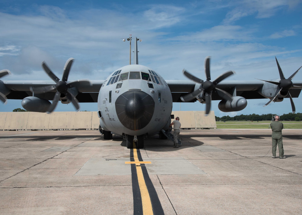
Formed in the 1940s, after World War II pilots dared each other to fly into a hurricane, the Hurricane Hunters, as the squadron is known, today boasts 10 C-130 cargo planes, called WC-130Js, modified with weather-reading instruments, extra fuel capacity and chutes to deploy dropsondes, which are cardboard tubes containing data-gathering instruments. The squadron maintains 20 air crews of five to six officers, who fly the missions at the request of the National Hurricane Center, which is part of National Oceanic and Atmospheric Administration. The Hurricane Hunters can fly up to three missions at once.
Last year, the squadron flew into hurricanes Katia, Irma and Jose simultaneously, the first time since 2010 three missions were flown at once. In fact, 2017 was its 10th-busiest season. The squadron flew 12 named storms, for 90 missions in total. This season, which ends November 30, the Hurricane Hunters have flown about 30 missions, two at the same time, when Florence was headed toward North Carolina and Olivia was off the coast of Hawaii.
The purpose is to launch dropsondes into the storm to collect information on moisture content, wind speed and direction, temperature, and atmospheric pressure inside the hurricane. The National Hurricane Center uses the data for forecasts and advisories.
“The data that we collect is very important,” Lt. Col. Cross said, referring to its use in advisories that warn of danger. “It’s highly valued because, bottom line, we are saving lives.”
These missions are more critical now because of global warming’s impact. Greenhouse gas buildup in the atmosphere, largely from burning fossil fuels and other human activities, has been warming the ocean’s surface. A United Nations Report, released two days before Lt. Colonel Cross took his crew into Michael, warned that carbon emissions needed to be drastically reduced in the next decade to avoid increased risks of extreme weather events.
As Michael intensified, water temperatures in the Gulf measured 83 to 84 degrees, three to four degrees warmer than average for this time of year. Warm water is hurricane fuel. The warmer the water, the faster storms grow.
Michael went from a tropical storm blowing 35 miles per hour on October 7 to a category 4 behemoth 72 hours later.
“I’m in disbelief at how this intensified right at landfall, so late in the year, in this part of Gulf, so quickly,” Truchelut, the meteorologist, said.
Rapid intensification of hurricanes is not well understood. Michael gained strength right up to landfall, uncommon for northern Gulf hurricanes, which often weaken due to dry air from land. But a jet stream to the north aided Michael’s outflow, according to Andy Hazelton, with NOAA’s Hurricane Research Division and the University of Miami.
Climate scientists don’t know for certain what the future holds for notoriously unpredictable hurricanes in a warmer climate. Some long-range modeling indicates slightly fewer but more powerful storms decades from now. With the water staying warm longer, hurricane seasons may lengthen. Other studies indicate that the large-scale wind patterns that traditionally guide hurricanes are slowing or weakening, allowing storms to linger and release more rain.
Meanwhile, wind speeds are likely to increase. Timothy Hall, with NASA’s Goddard Institute for Space Studies in New York City, explained that while the ocean is warming, the upper atmosphere is not. The temperature difference is driving up hurricane intensity. Some storms, he said, “will reach intensities never seen historically.”
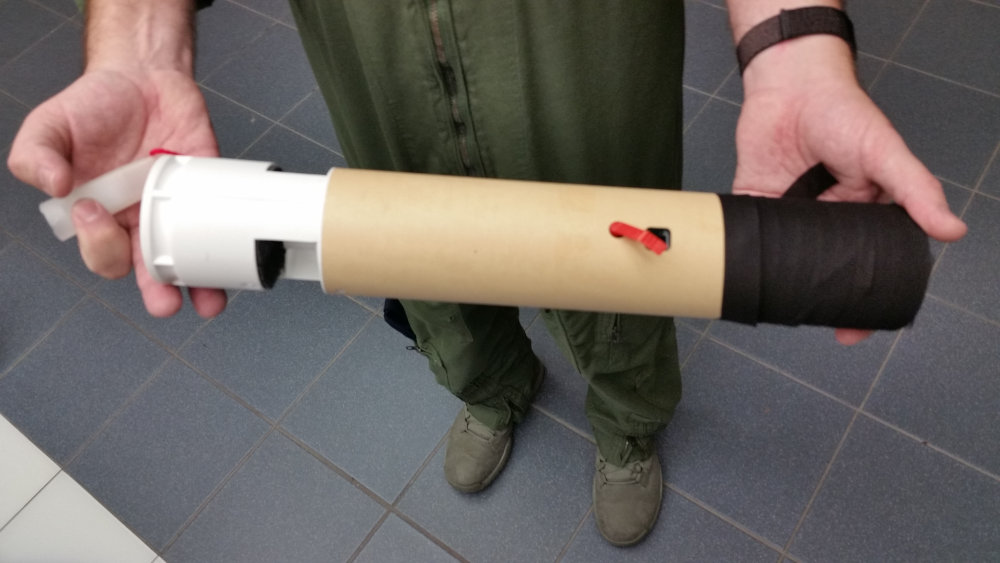
Dropsondes are cardboard tubes containing data-gathering instruments. (Photo by Tristram Korten.)
If hurricane activity does intensify, Hurricane Hunter flights may get more dangerous than they already are. Between 1945 and 1974, six U.S. military planes have been lost tracking hurricanes, five over the Pacific and one over the Caribbean.
The flight through Michael offered a potent reminder of those risks. During the fourth and final penetration into the eye, the plane hit violent turbulence as it was about to break through the eyewall. The plane entered a pocket and dropped up to 2,000 feet. Passengers not strapped in flew inches above their seats and loose containers launched more than a foot in the air.
After breaking through the wall and stabilizing, the plane followed the 10,000-foot pressure gradient toward the eye. Michael’s pressure was so low, and the plane’s descent so steep, Gentile had to take the controls from the autopilot to keep from descending farther. To climb back out, Gentile fed near-maximum thrust to the engines.
“The section that we were going into was a really rough patch of turbulence. The autopilot kicked off, and you basically have to hand fly it,” said Gentile, one of the squadron’s newest pilots. Michael was only his fourth hurricane mission. “And that’s, I guess, what they pay us for,” he joked.
Or, as Lt. Col. Cross put it: “Hurricane Michael had a hold of us and he was doing what he wanted to with the plane. For about 30 seconds there, it was pretty intense. It was a ride I’m not going to forget for the rest of my career.”
As the plane sped across the eye, the men in the cockpit gazed two miles below, where whitecaps from Michael’s roiling storm surge could be seen crashing onto the shore. This was the moment of landfall, near Port St. Joe. It was a milestone for the hurricane hunters, whose missions routinely end before the storm reaches land.
“I don’t know anybody else in the squadron that has seen that as long as I’ve been doing it,” said Cross, who has been flying into hurricanes for 18 years.
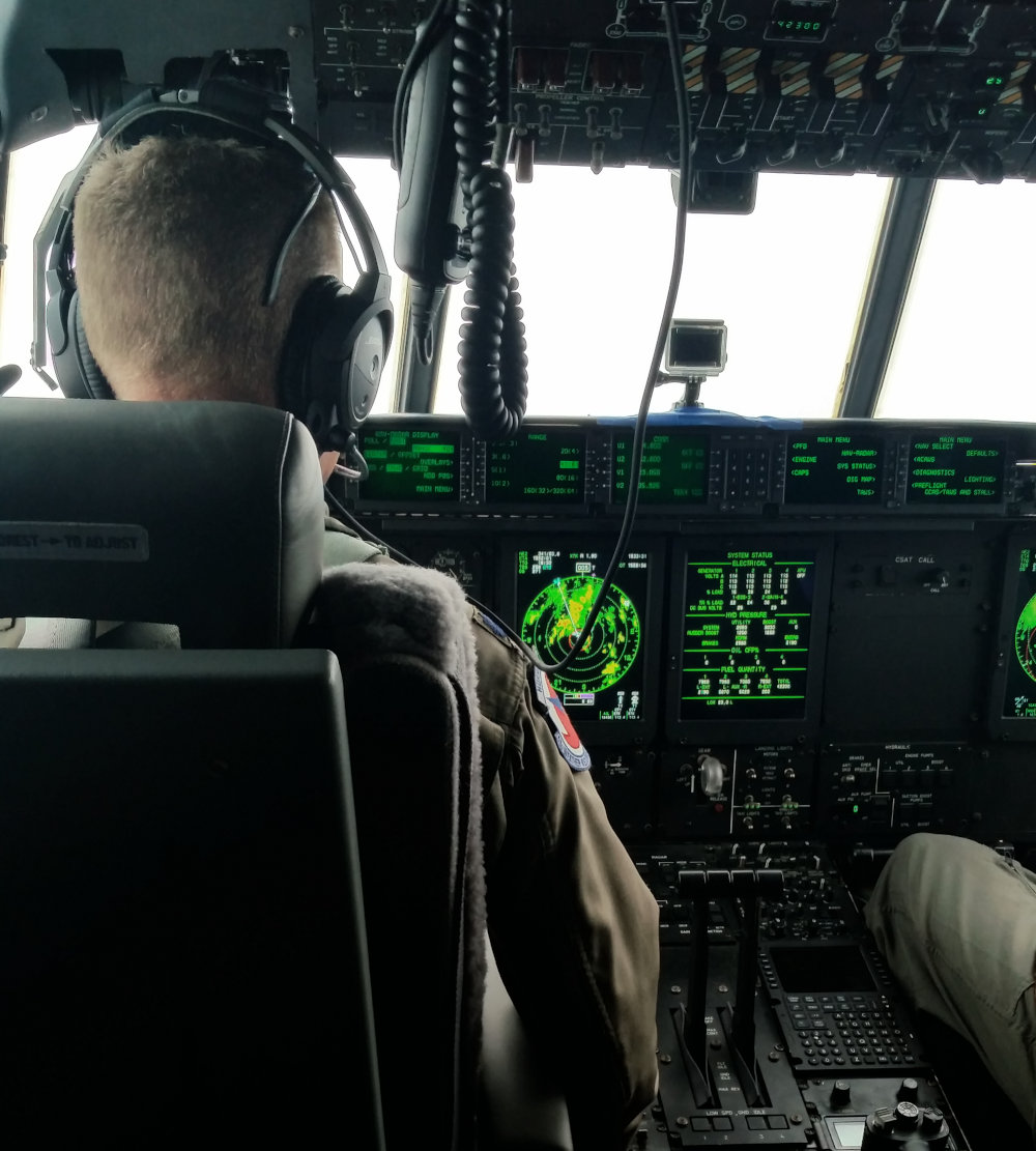
Lt. Col. Sean Cross of the 53rd Weather Reconnaissance Squadron pilots the plane into the eye of Hurricane Michael on October 10. (Photo by Tristram Korten.)
For Lt. Col. Cross, Michael was not just a mission seen from above. It was personal. His parents live in the Panhandle, and he was desperate to hear if they were safe. After landing, he rushed to turn on his phone.
“I’m planning on driving over tomorrow,” he said outside the plane, choking up slightly. “My heart goes out to all my friends and neighbors in that small community.”
Then, before heading inside, he added: “I’m going to have a beer too. That was a long day.”

Tristram Korten is a journalist and author based in Miami. His book Into The Storm was published by Ballantine in 2018.